Aktywne Wpisy

markedone +115
W Australii zostało zagubione źródło promieniotwórcze.
Jest to źródło Cs-137 o aktywności 19 GBq i wymiarach 8 mm średnicy i 6 mm wysokości.
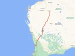
Źródło zostało zgubione gdzieś pomiędzy Perth a Newman.
Moc dawki pochłoniętej z odległości jednego metra od takiego źródła to około 0,399 cGy/h co odpowiada mocy dawki równoważnej 4,58 mSv/h.
Żeby mieć jakieś odniesienie, dawka graniczna dla osób z ogółu ludności równa jest 1 mSv/rok, stojąc w odległości 1 m
Jest to źródło Cs-137 o aktywności 19 GBq i wymiarach 8 mm średnicy i 6 mm wysokości.
Źródło zostało zgubione gdzieś pomiędzy Perth a Newman.
Moc dawki pochłoniętej z odległości jednego metra od takiego źródła to około 0,399 cGy/h co odpowiada mocy dawki równoważnej 4,58 mSv/h.
Żeby mieć jakieś odniesienie, dawka graniczna dla osób z ogółu ludności równa jest 1 mSv/rok, stojąc w odległości 1 m

EtaCarinae +7
#ukraina ludzie nie mają co jeść a Zełenski w ciuchach Maserati się lansuje.


2. only for distance?
3. If instrument is not level, how can readings be accurate ?
#geodezja
@dropz także chętnie zobaczyłbym źródło